![](/images/other/stat-length.png)
![Trail Walking Le Hézo - Le Hezo - Ile Tascon A/R - Photo](https://media.geolcdn.com/t/1900/400/ext.pjpeg?maxdim=2&url=https%3A%2F%2Fstatic1.geolcdn.com%2Fsiteimages%2Fupload%2Ffiles%2F1553511878bg_sport_marche.png)
Le Hezo - Ile Tascon A/R
Cladichelancien
User
![Length](/images/other/stat-length.png)
Length
17.8 km
![Max alt](https://static1.geolcdn.com/siteimages/upload/files/1508320355ic_sort_altitude_max_24dp.png)
Max alt
11 m
![Uphill gradient](https://static1.geolcdn.com/siteimages/upload/files/1508320355ic_sort_den_pos_24dp.png)
Uphill gradient
72 m
![Km-Effort](/images/other/stat-length.png)
Km-Effort
18.7 km
![Min alt](https://static1.geolcdn.com/siteimages/upload/files/1508320355ic_sort_altitude_min_24dp.png)
Min alt
-5 m
![Downhill gradient](https://static1.geolcdn.com/siteimages/upload/files/1508320355ic_sort_den_neg_24dp.png)
Downhill gradient
72 m
![Boucle](https://static1.geolcdn.com/siteimages/upload/files/16400158638029165_repeat_loop_refresh_sync_direction_icon.png)
Boucle
Yes
Creation date :
2019-06-13 21:36:19.915
Updated on :
2019-06-14 19:16:58.777
![Walking](https://static1.geolcdn.com/sitytour/trail-icons/101.png)
4h11
Difficulty : Easy
![Scan this QR Code to open this trail in the SityTrail application](https://capi.geolives.com/qq0zvz2zws4bq2lad0pu/sitytour/trails/2113363/qr.png?size=200)
FREE GPS app for hiking
About
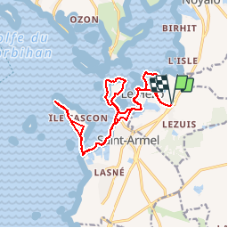
Trail Walking of 17.8 km to be discovered at Brittany, Morbihan, Le Hézo. This trail is proposed by Cladichelancien.
Description
Départ/Arrivée Le Hézo Parking face au Musée Rue Lann Vrihan
ATTENTION : VÉRIFIEZ LES HORAIRES DE LA MARÉE POUR PASSER SUR L' ÎLE TASCON.
Positioning
Country:
France
Region :
Brittany
Department/Province :
Morbihan
Municipality :
Le Hézo
Location:
Unknown
Start:(Dec)
Start:(UTM)
523092 ; 5269927 (30T) N.
Comments
Trails nearby
![Trail Walking Saint-Armel - Tour du Golfe du Morbihan - 04 - St Armel, Le Hézo - Photo](https://media.geolcdn.com/t/375/260/ext.jpg?maxdim=2&url=https%3A%2F%2Fservices.sitytrail.com%2FGeolivesWS%2FDownloadMedia.ashx%3FTrailID%3D109034%26Media%3D3000_2.jpg)
![Walking Walking](https://static1.geolcdn.com/sitytour/trail-icons/101.png)
Tour du Golfe du Morbihan - 04 - St Armel, Le Hézo
Walking
Difficult
(1)
Saint-Armel,
Brittany,
Morbihan,
France
![](/images/other/stat-length.png)
16.6 km | 17.6 km-effort
4h 0min
![](https://static1.geolcdn.com/siteimages/upload/files/16400158638029165_repeat_loop_refresh_sync_direction_icon.png)
No
![Trail Walking Saint-Armel - Île TASCON- Le Passage 56 - Photo](https://media.geolcdn.com/t/375/260/ext.jpg?maxdim=2&url=https%3A%2F%2Fstatic1.geolcdn.com%2Fsiteimages%2Fupload%2Ffiles%2F1553511878bg_sport_marche.png)
![Walking Walking](https://static1.geolcdn.com/sitytour/trail-icons/101.png)
Île TASCON- Le Passage 56
Walking
Easy
(1)
Saint-Armel,
Brittany,
Morbihan,
France
![](/images/other/stat-length.png)
11.5 km | 12.1 km-effort
2h 31min
![](https://static1.geolcdn.com/siteimages/upload/files/16400158638029165_repeat_loop_refresh_sync_direction_icon.png)
Yes
![Trail Walking Saint-Armel - St Armel en passant par l'Ile de Tason (Boucle) - Photo](https://media.geolcdn.com/t/375/260/ext.jpg?maxdim=2&url=https%3A%2F%2Fstatic1.geolcdn.com%2Fsiteimages%2Fupload%2Ffiles%2F1553511878bg_sport_marche.png)
![Walking Walking](https://static1.geolcdn.com/sitytour/trail-icons/101.png)
St Armel en passant par l'Ile de Tason (Boucle)
Walking
Medium
(3)
Saint-Armel,
Brittany,
Morbihan,
France
![](/images/other/stat-length.png)
20 km | 22 km-effort
4h 49min
![](https://static1.geolcdn.com/siteimages/upload/files/16400158638029165_repeat_loop_refresh_sync_direction_icon.png)
Yes
![Electric bike Electric bike](https://static1.geolcdn.com/sitytour/trail-icons/205.png)
Boucle De Surzur à Ambon
Electric bike
Medium
Surzur,
Brittany,
Morbihan,
France
![](/images/other/stat-length.png)
16 km | 17.6 km-effort
1h 15min
![](https://static1.geolcdn.com/siteimages/upload/files/16400158638029165_repeat_loop_refresh_sync_direction_icon.png)
Yes
![Trail Walking Séné - PR_56_Sene_IA_09_Circuit1b_Sentier-Des-Gabelous_20240311 - Photo](https://media.geolcdn.com/t/375/260/c2ea644e-e03f-4409-ac55-71c5dee67584.jpg&format=jpg&maxdim=2)
![Walking Walking](https://static1.geolcdn.com/sitytour/trail-icons/101.png)
PR_56_Sene_IA_09_Circuit1b_Sentier-Des-Gabelous_20240311
Walking
Very easy
Séné,
Brittany,
Morbihan,
France
![](/images/other/stat-length.png)
10.1 km | 11 km-effort
1h 53min
![](https://static1.geolcdn.com/siteimages/upload/files/16400158638029165_repeat_loop_refresh_sync_direction_icon.png)
Yes
![Trail Walking Sarzeau - PR_56_Sarzeau_EA_05_Circuit1b_Au-Coeur-De-La-Foret_20240202 - Photo](https://media.geolcdn.com/t/375/260/8e54e8bd-ca94-4a5c-b265-446ad8267cc7.jpg&format=jpg&maxdim=2)
![Walking Walking](https://static1.geolcdn.com/sitytour/trail-icons/101.png)
PR_56_Sarzeau_EA_05_Circuit1b_Au-Coeur-De-La-Foret_20240202
Walking
Very easy
Sarzeau,
Brittany,
Morbihan,
France
![](/images/other/stat-length.png)
12.3 km | 13.2 km-effort
3h 0min
![](https://static1.geolcdn.com/siteimages/upload/files/16400158638029165_repeat_loop_refresh_sync_direction_icon.png)
Yes
![Trail Walking Saint-Armel - PR_56_St-Armel_AA_01_Circuit1b_Le-Marais-Salant-De-Lasne_20231222 - Photo](https://media.geolcdn.com/t/375/260/0843618c-a073-4181-b237-858d69aa3eda.jpg&format=jpg&maxdim=2)
![Walking Walking](https://static1.geolcdn.com/sitytour/trail-icons/101.png)
PR_56_St-Armel_AA_01_Circuit1b_Le-Marais-Salant-De-Lasne_20231222
Walking
Very easy
Saint-Armel,
Brittany,
Morbihan,
France
![](/images/other/stat-length.png)
12.6 km | 13.4 km-effort
2h 39min
![](https://static1.geolcdn.com/siteimages/upload/files/16400158638029165_repeat_loop_refresh_sync_direction_icon.png)
Yes
![Trail Walking Séné - PR_56_Sene_HA_08_Circuit3a_Du-Passage_20231205 - Photo](https://media.geolcdn.com/t/375/260/d5b7643d-c63d-4161-aaf0-6fe7e6e442e1.jpg&format=jpg&maxdim=2)
![Walking Walking](https://static1.geolcdn.com/sitytour/trail-icons/101.png)
PR_56_Sene_HA_08_Circuit3a_Du-Passage_20231205
Walking
Medium
Séné,
Brittany,
Morbihan,
France
![](/images/other/stat-length.png)
8.5 km | 9.7 km-effort
1h 47min
![](https://static1.geolcdn.com/siteimages/upload/files/16400158638029165_repeat_loop_refresh_sync_direction_icon.png)
Yes
![Trail Walking Séné - PR_56_Sene_GA_07_Circuit3b_Entre-Bocage-Et-Marais_20231115 - Photo](https://media.geolcdn.com/t/375/260/90de986c-3b14-49b7-b42b-f41416db033a.jpg&format=jpg&maxdim=2)
![Walking Walking](https://static1.geolcdn.com/sitytour/trail-icons/101.png)
PR_56_Sene_GA_07_Circuit3b_Entre-Bocage-Et-Marais_20231115
Walking
Medium
Séné,
Brittany,
Morbihan,
France
![](/images/other/stat-length.png)
7.8 km | 8.3 km-effort
1h 30min
![](https://static1.geolcdn.com/siteimages/upload/files/16400158638029165_repeat_loop_refresh_sync_direction_icon.png)
Yes